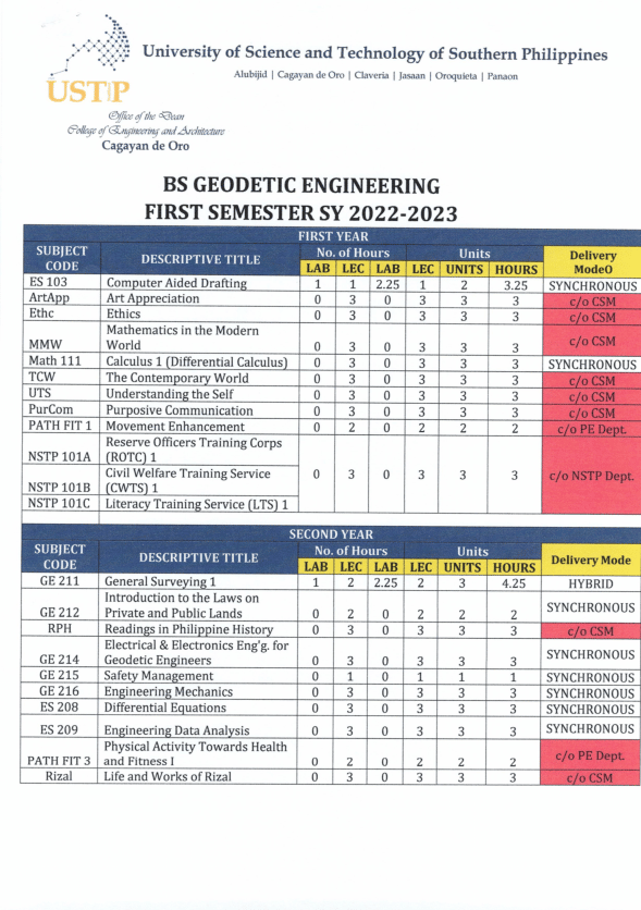
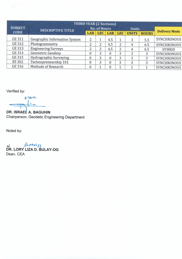
MODALITY OF CLASSES


ABOUT THE PROGRAM
The Bachelor of Science in Geodetic Engineering is a four-year degree program dealing with the collection and measurement of spatial data on the surface of the earth using appropriate technologies and precision instruments. The program teaches students scientific and methodological processing and management of gathered data for the production of spatial information systems, maps, plans, charts, and other relevant documents. It aims to make students knowledgeable of geographical information systems and positioning systems to develop their skills in astronomical observations.
PROGRAM OUTCOMES
a.) Apply knowledge of mathematics, geology, physics, biology, information technology and other engineering principles.
b.) Identify, formulate, research literature and analyze complex engineering problems reaching substantiated conclusions using first principles of mathematics, natural sciences and engineering sciences.
c.) Design solutions for complex engineering problems and design systems, components or processes that meet specified needs with appropriate consideration for public health and safety, cultural, societal and environmental considerations.
d.) Conduct investigation of complex problems using research-based knowledge and research methods including design of experiments, analysis and interpretation of data, and synthesis of information to provide valid conclusion.
e.) Create, select and apply appropriate techniques, resources and modern engineering and information technology (IT) tools, including prediction and modelling, to solve complex engineering problems, with an understanding of the limitation.
f.) Apply reasoning informed by contextual knowledge to assess societal, health, safety, legal and cultural issues and the consequent responsibilities relevant to the professional engineering practice and solutions to complex engineering problems.
g.) Understand and evaluate the sustainability and impact of the professional engineering work in the solution of complex engineering problems in societal and environmental contexts.
h.) Apply ethical principles and commit professional ethics, responsibilities and norms of engineering practice.
i.) Function effectively as an individual, and as a member or leader in diverse terms and in multi- disciplinary settings.
j.) Communicate effectively on complex engineering activities with the engineering community and with society at large, such as being able to comprehend and write effective reports and design documentation, make effective presentations, and give and receive clear instructions.
k.) Demonstrate knowledge and understanding of engineering management principles and economic decision-making and apply these to one’s own work, as a member or a leader in a team, to manage projects and in multidisciplinary environments.
l.) Recognize the need for, and have the preparation and ability to engage in independent, and life-long learning in the broadest context of technological change.
m.) Understand at least one focus area of geodetic engineering practice and apply such knowledge to provide solutions to actual problems.
CAREER OPPORTUNITIES
- Graduate in Geodetic Engineering


